Tsunamit
Japani 2011
Japanin vuoden 2011 tsunami linkkikatsauksena (Lisää materiaalia näiden sivujen linkeissä)
- Neljä junaa kateissa Japanissa – kuolleiden määrä nousee | Japanin tsunami | Teemat | YLE Uutiset | yle.fi 11.3.2011 klo 8:02
- Tulipalot raivoavat Japanissa – valtavat tuhot tsunamista | Japanin tsunami | Teemat | YLE Uutiset | yle.fi 11.3.2011 klo 9:55
- Kuvagalleria: Japanin tsunami | Japanin tsunami | Teemat | YLE Uutiset | yle.fi 11.3.2011 klo 10:18
- Tsunamiaalto pyyhkii Tyynellämerellä – vahingot pieniä | Japanin tsunami | Teemat | YLE Uutiset | yle.fi 11.3.2011 klo 10:44
- Tsunami teki tuhojaan Kaliforniassa | Japanin tsunami | Teemat | YLE Uutiset | yle.fi 11.3.2011 klo 15:50
- Kuva kuvalta: Kuinka tsunami syntyy ja iskee | Japanin tsunami | Teemat | YLE Uutiset | yle.fi 11.3.2011 klo 17:27
- Aamu paljasti valtavat tuhot Japanissa | Japanin tsunami | Teemat | YLE Uutiset | yle.fi 12.3.2011 klo 0:48
- Tsunamin alkuhetket vangittu | Japanin tsunami | Teemat | YLE Uutiset | yle.fi 13.3.2011 klo 10:08
- Tsunami pyyhki kokonaisia kyliä mukanaan – tuhansia ihmisiä etsitään | Japanin tsunami | Teemat | YLE Uutiset | yle.fi 15.3.2011 klo 14:27
- Jättimäinen Japanin tsunamista aiheutunut rojulautta kelluu Tyynellämerellä | Japanin tsunami | Teemat | YLE Uutiset | yle.fi 10.4.2011
Englanniksi
- BBC News – Tsunami hits north-eastern Japan after massive quake 11 March 2011
- Massive earthquake hits Japan – The Big Picture – Marc 11 Boston.com
- Earthquake Is Biggest in Japan’s Recorded History | Wired Science | Wired.com
- Massive 8.9 quake, tsunamis hit Japan – CNN.com March 12, 2011
- BBC News – Japan quake: Worst crisis since WWII, says PM 14 March 2011
- ABC News Japan Earthquake: before and after
- Satellite Photos – Japan Before and After Tsunami – Interactive Feature – NYTimes.com
- Special report: After Japan’s megaquake – New Scientist
Koontia tsunamin aiheuttamasta ydinonnettomuudesta
- Japanin ydinvoimalassa räjähdys – video räjähdyksestä | Japanin tsunami | Teemat | YLE Uutiset | yle.fi; 12.3.2011
- Japan’s nuclear crisis: The story so far – environment – 15 March 2011 – New Scientist
- Why Fukushima Daiichi won’t be another Chernobyl – physics-math – 17 March 2011 – New Scientist
- Understanding Japan’s Nuclear Crisis | Wired Science | Wired.com 18.3.11
- BBC News 21 March 2011 – Japan nuclear emergency ongoing as tsunami toll rises
- BBC News – Japan nuclear crisis ’will be overcome’, says IAEA 21 March 2011
- BBC News – 23 March 2011 Tokyo water ’unfit for babies’ due to high radiation
- BBC News – Japan nuclear plant: Radioactivity rises in sea nearby 26 March 2011
- Tepco: Japanin huima säteilytulos oli mittausvirhe | Japanin tsunami | Teemat | YLE Uutiset | yle.fi 27.3.2011
- Fukushiman reaktorirakennuksesta valui radioaktiivista vettä – HS.fi – Ulkomaat 28.3.2011
- BBC News – 29 March 2011 Japan nuclear: PM Naoto Kan signals ’maximum alert’
- Fukushiman onnettomuus aiheutti perhosissa vakavia mutaatioita | Yle Uutiset | yle.fi; 14.8.2012
- STUK Fukushima Dai-ichi-ydinvoimalaitoksen onnettomuus
- Twitter-virtaa
(Tilanne ei suinkaan vielä ole ohi!)


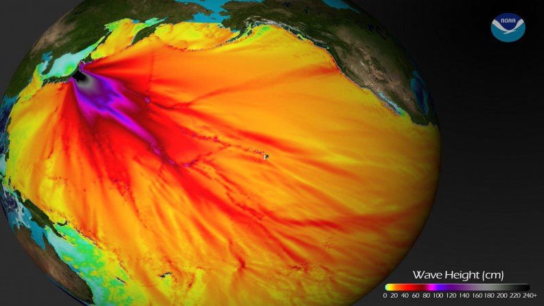

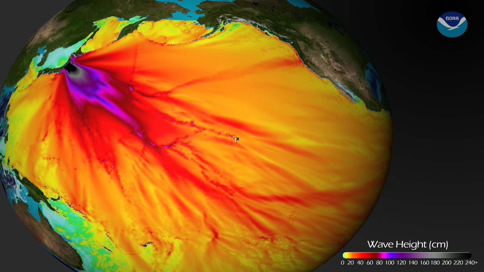

Calculated wave height of the 2011 tsunami originating near Sendai, Japan (from NOAA computer model). ; By NOAA [Public domain], via Wikimedia Commons

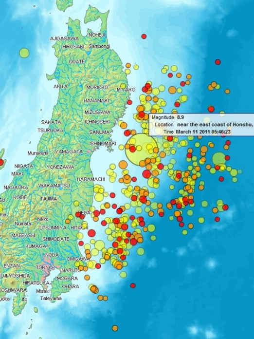
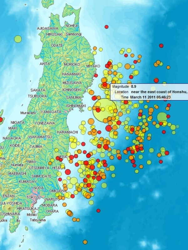

Cropattu kuvasta: Map of the Sendai Earthquake 2011 and aftershocks until March 14, 2011 at 11:20. The size of the circles is a function of magnitude, and the color indicates the date: light green: March 11; yellow: March 12; orange: March 13; red: March 14.;By www2.demis.nl, Uploader User:Heinz-Josef Lücking (http://www2.demis.nl/quakes/) [Public domain, Public domain or CC0], via Wikimedia Commons

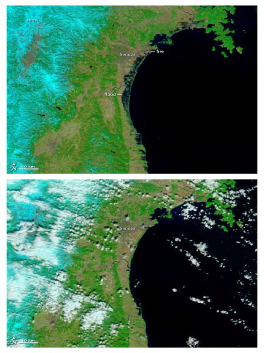
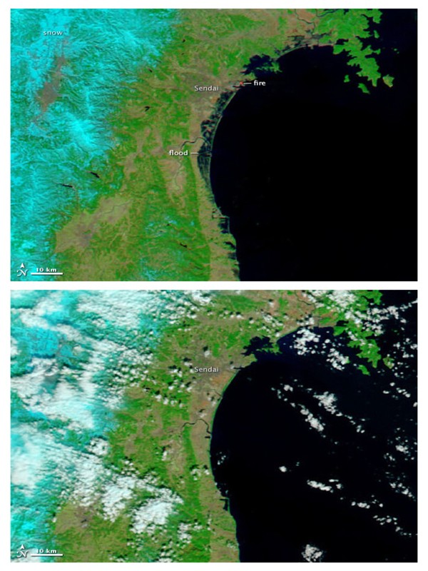

Skies over northeastern Japan were entirely cloud-free on March 13, 2011, providing a clear view of tsunami flooding along the coastline. Water, black and dark blue in these false-color images, still covers the ground as much as five kilometers (three miles) from the coast. The lower image, taken on February 26, 2011, shows the coastline under normal conditions.; By NASA / Goddard Space Flight Center [Public domain], via Wikimedia Commons